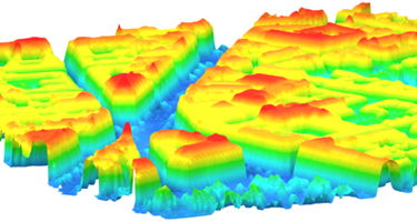
We have adapted our unique and general 3D mathematical modeling technology to be used with airborne laser mapping data. The result is a compact software module (a dll) that is easily integrated into an application. This means that the module may painlessly replace your current triangulation module, allowing you to maintain any pre- or postprocessing.
A lot of unique capabilities are realized because a mathematical model is generated as an intermediary phase between the raw data and the resulting CAD model.

- We think the high quality speaks for itself
- It is insensitive to unevenly distributed data
- The data and output face resolutions are independent
- So are the surface smoothness and the face resolution
- The resulting surface is free of inconsistencies
- The software performs at very high speed